|
|  |
|
The river was first mapped by French explorers in 1688, but detailed, accurate mapping did not occur until the great astronomer and cartographer, Joseph Nicolett,(http://swcc.cc.sd.us/sitenic.htm) along with his assistant, the famed John C. Fremont, mapped the area in detail in 1839. The book by Martha Bray, Joseph Nicollet and His Map. 1994, has details of Nicolette's adventure and copies of his famous maps. For more info on the book, go to: http://www.powells.com/cgi-bin/biblio?inkey=4-087169140x-0

|
| Source of the Big Sioux |
|
|
|
| |
|
Photos on these pages were all taken by Mick Zerr. ( A description of the item, location, date,etc. accompanies each photo, if possible.)
|
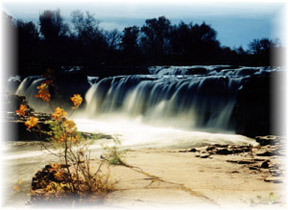
| 1 Falls of the Big Sioux River |
Falls of the Big Sioux River was taken in the autumn of 1995 facing ESE toward the falls on the Big Sioux River at Falls Park in Sioux Falls, SD.This photo, and all the others on this internet site are (Copyright 2002 Mick Zerr) For more info on Falls Park, go to: http://www.sioux-falls.org/index.asp

|
| 2 Panoramic view of Falls from East side of river |

|
| 3 Big Sioux falls in winter from west side of river. |
|
|
|
|
|

|
| 4 Summer Falls |

|
| 5 Close up of the Falls |
The Falls close up offer spray and mist as well as the roar of millions of gallons of water falling over three stories.
 |
|
| |